
We love finding new places and sharing the places we know with others. All our walks are led by members of the group. If you would like to lead a walk for us and have not led before leading your first walk can be a rewarding experience. We’ve put this simple guide together to help guide you through leading a walk for us.
Step 1: Let us Know You’d Like to Lead

Please email us at
Step 2: Get Some Training (optional)

Go for a practice walk or ‘reccy’ to ensure you can find your way around the route and to check for potential hazards or problems such as busy roads, impassable paths or a weekend market in your chosen car park. It is good to reccy your walk with a potential backmarker so they become familiar with the route, this is not essential. Some people do a reccy before they put a walk on the calendar to be certain its correct, others who might know the area will walk it closer to the walk date to check for any issues.
Looking for new Routes?
Not sure where to start, there are lots of books, websites and apps with suggested routes and descriptions for you to choose from, or for more flexibility and endless possibilities make up a route yourself from a map. Some suggestions are:-
- Ramblers Routes (you need to log in to see longer route details in full or use the Rambler App to view routes nearby
- Our Group Walks Archive for start points and descriptions of previous walks
- Chiltern Society Walk leaflets
- Bucks Walks list on Walking in England
- Bucks Walks list on Walking Britain
Path problems
Some walks in our area may be affected by the construction of HS2. Buckinghamshire County Council have published HS2 Rights Of Way Changes for details of closures and diversions caused by HS2. The public rights of way network in the Chilterns is generally in a good state. Occasionally, you may encounter issues such as paths blocked by overgrown vegetation, a fallen tree or other obstructions or broken stiles, signposts, gates. Take a photo and note the location. Path issues in Buckinghamshire can be reported via Report an Issue. This will help to ensure that other walkers do not experience the same problem.
Step 4: Put your walk in the calendar
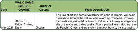
See the pinned post in the Facebook group to access the walks spreadsheet or email
- Title: A short and interesting description of your walk to make people want to read more. A good format is where you will start and somewhere the walk goes to or will see e.g. Wendover and Coombe Hill Panoramic Views.
- Walk description: Your chance to really sell your walk. Include information so people want to come along and know what to expect! Do people need to bring a packed lunch, are you planning on having a drink afterwards? If so, include it in the description.
- Circular/Linear: If you are planning a linear walk involving public transport include details in the description including costs and check for planned engineering works. It is often best to catch the bus/train at the start of the walk, rather than just missing it at the end.
- Distance: in miles by default
- Start time: if possible, its good to check public transport timetables, and start just after a bus or train is due to arrive, state you will wait for the train if that is the case.
- Starting point details: ensure there is enough parking at the start of the walk, most people will drive even if it is accessible by public transport. Generally, you should allow for 15-20 cars. You can see car parks used by all Ramblers groups on our Map of Car Parks. Right click on the map to show the grid reference and find a suitable post code.
- Grade: We use the Ramblers Walk grades descriptions, see the table below to compare.
- Estimated finish time: How long will your walk take? Our group usually walk about 2.5mph (4kph) on Leisurely walks and a little faster on Moderate walks including rest stops. Add time if there is a lunch or pub/cafe drinks stop in the middle of the walk, about 30 minutes for each. It’s likely a large group’s pace will be slower than with 1 or 2 other people especially with lots of stiles or kissing gates to slow the group down!
Once your walk has been listed on the website, you should check the details to ensure everything is correct.
Step 5: Complete a Risk Checklist
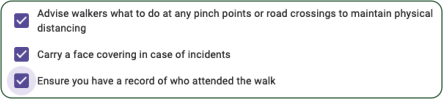
Answer the questions on the checklist (we’ll send this to you) to record you've thought about potential risks and issues.
Comparison of Ramblers Walk Grades

* Hills is a very broad term, everything from 30m to 500m+ ascent, individual ascent less than 100m is more like a steep path. There is almost no 'rough country' e.g. moorland in the Chiltern Hills. Consider average level of fitness and pace, people with a good level of fitness are usually comfortable walking 10 miles with 300-400m total undulating ascent which is common in the Chilterns (Moderate). When this increases to 13-14 miles and 500m+ ascent, the average person tends to really struggle towards the end. Consider upgrading to Strenuous if you're unsure. There are also Easy Access and Technical grades, see Ramblers walks grades for more information.